Barada: A Corridor of Sacrifice
Walaa Hajali
How can a river be both a victim of and a witness to the fragile urban reality flowing through the city?
Barada, through which the urban-natural synthesis of Damascus is continually negotiated. While the relationship of the city with the main river of Damascus was not only about irrigation and drinking water, the Barada river, the iconic significance of the river is inseparable from the identity of Damascus itself.
The symbolic importance of the main river of Damascus takes center stage whenever the river overflows. However, the paradox of the vibrant scenes of Damascenes celebrating the abundance of Barada in the peak flow period and its lived vulnerability, experienced through dryness and contamination reveals the river as a multifaceted landscape.
Flowing through three contrasting natural landscapes, including the upstream areas of Barada Valley, the city of Damascus, and Al Ghouta orchards that once formed a continuous green boundary around the city, Barada serves as a connective urban infrastructure between the city of Damascus, the rural hinterland, and the mountains, shaping both the urban and natural landscapes of the region (Tabbarah, 2025). While the spatial continuation of the river on official maps of Damascus still acknowledges the historical and natural presence of the Barada river as an ecological corridor, it appears yet on the ground as a continuous corridor of sacrificed water, but in different modes.
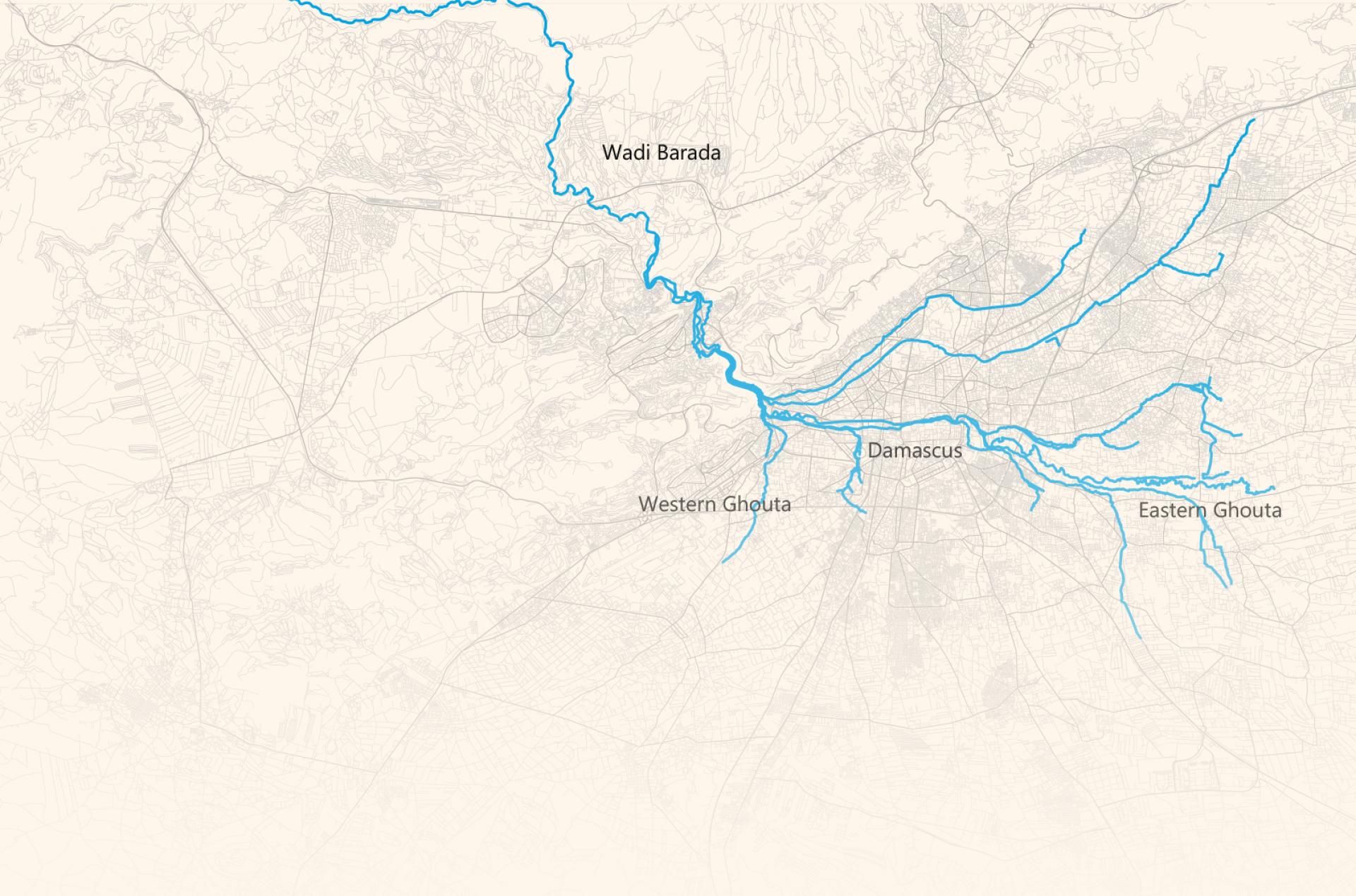
Barada as a continuous spatial element: On official maps of Damascus, the river illustrates continuity across the Barada valley (Wadi Barada), the city itself, and its sourrounding hinterland (Al-Ghouta).
Upstream in the Barada valley, the contamination of the river becomes ordinary long before it becomes politically visible. Fragility, as Nixon (2011) suggests, often emerges through the sedimentation of everyday decisions: what is repaired, what is allowed to deteriorate, and what levels of damage are normalized as “acceptable loss.” In Wadi Barada, population growth and urban expansion, combined with regulatory absence and profit-driven urbanism enabled private estates and businesses to discharge wastewater into the river without accountability. In other neighborhoods along the river’s lower terrains of the valley, such as al-Hama and Dummar, exposure here is particularly domestic: odor in summer heat, mosquitoes, and polluted water. Yet residents are not only exposed; they are also entangled in the river’s degradation. In the absence of adequate sewage, household wastewater is fed into Barada directly making communities part of the pollution pathway, even as they live with its consequences.
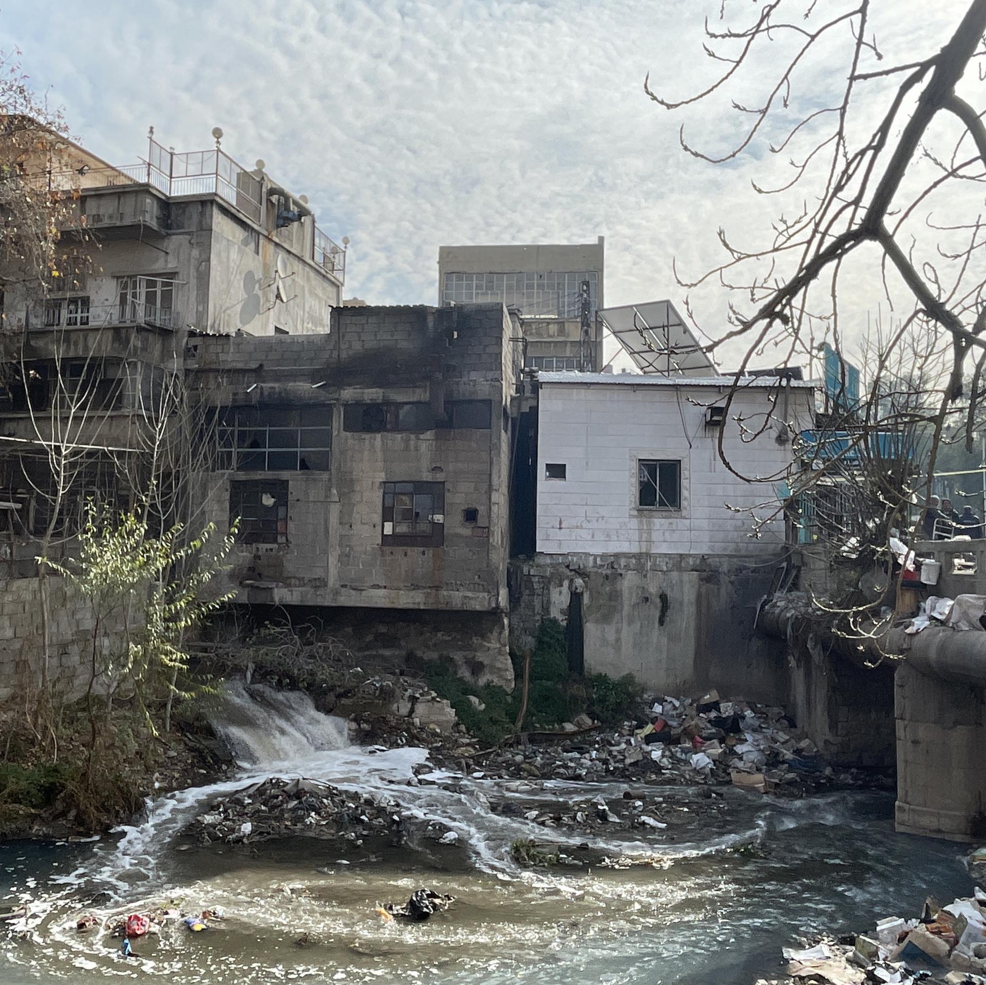
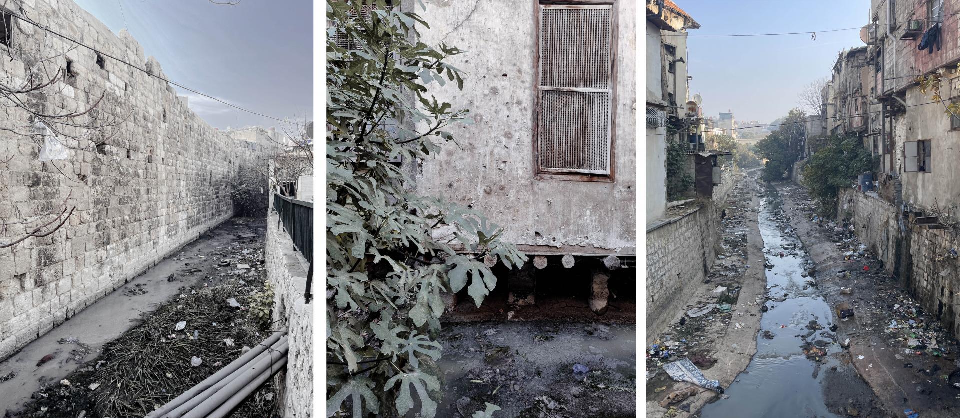
Barada as a background corridor: Where the density of the city’s everyday life emerges with sewage pathways and the contaminated river of Barada. Photo by the author (December 2025)
Across the urban core of Damascus, ecology becomes infrastructure. Water stress intensifies through “improvements” that reorganize the river as a network of managed passages. Visibility is something secured within concrete boundaries, while the river is treated in certain spaces as a hydraulic inconvenience and hidden under urban networks. Paving and sealing sections of the riverbed along the main streets of the city and in the prestigious districts of Damascus were justified as maintenance and control. However, while these measures organize surfaces, they dismantle the ecological life of the river by accelerated flow and reduced infiltration.
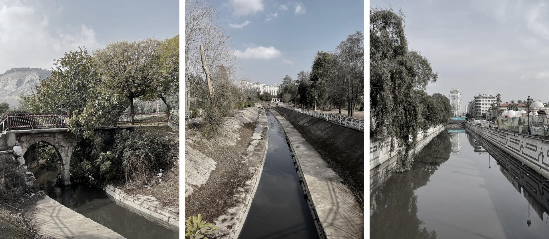
Barada as a controlled corridor: in the urban core of Damascus, Barada is progressively optimized for control rather than resilience. It remains within concrete boundaries, and eventually disappears into pipes as an act of hygienic control that records ecological variability as a threat to be managed. Photos by the author (December 2025)
Barada as a controlled corridor: in the urban core of Damascus, Barada is progressively optimized for control rather than resilience. It remains within concrete boundaries, and eventually disappears into pipes as an act of hygienic control that records ecological variability as a threat to be managed. Photos by the author (December 2025)
In the hidden urban infrastructures of the city, exemplified by the tight urban passages of old Damascus, where the river plays a diminished role in the symbolic landscape, harm accumulates incrementally through neglect, solid waste and discharging untreated residential and industrial waste directly into the river.
The spatial marginalization of Barada emphasizes an active disconnection from the city and along its continuing course, transforming a historic waterway into one of environmental collapse of the urban reality of the city.
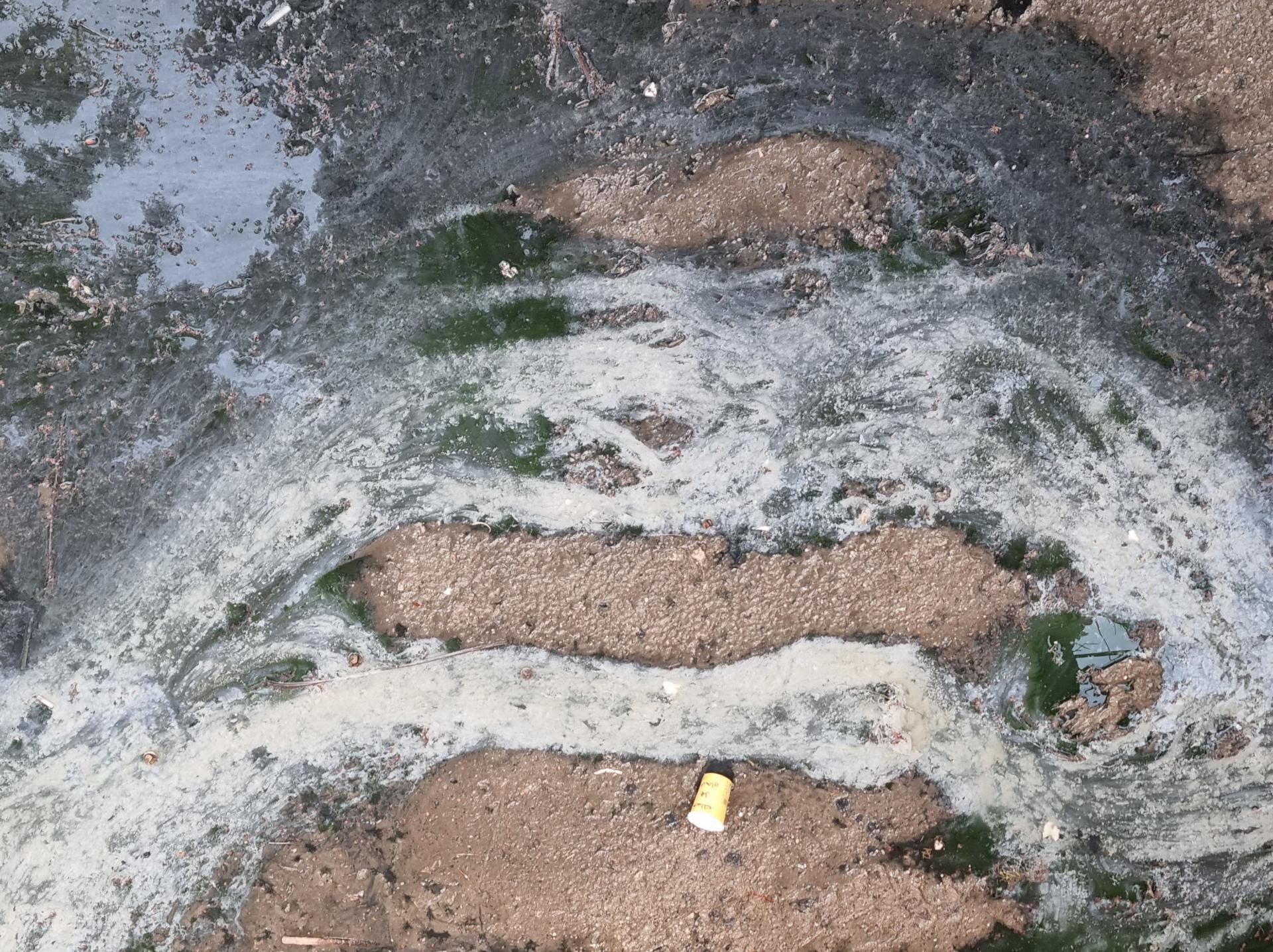
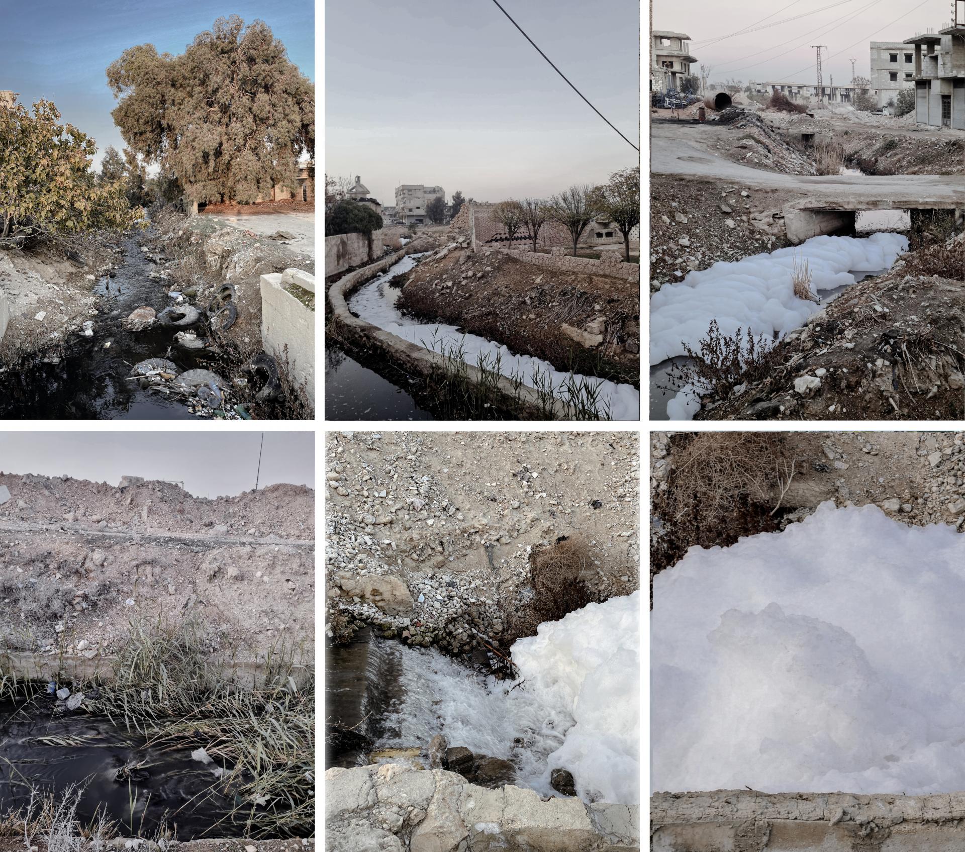
Downstream in Ghouta, much of the lower course flow has been drastically reduced, and Barada increasingly survives on wastewater and storm runoff rather than sustained water. In dry periods, it runs as an exposed and contaminated channel, carrying what the city cannot (or will not) contain. Agricultural lands particularly suffer from polluted canals, transforming the river into a disposal corridor rather than a shared landscape. However, intensified agriculture and fertilizers sustains the contaminated legacy of the river. Moreover, unregulated industries in the outskirts of Damascus overwhelm the river’s canals through chemical pollutants. The scenes of chemical foams frequently characterize the river’s surface in these neighborhoods as the wide marble and concrete facilities signifies an ecological failure to the river infrastructure, discharging untreated industrial wastewater into the river.
Accordingly, river flow decline led to higher pollutant concentrations, transferring the environmental burdens of the city to Ghouta, which functions as the outside of the river ecosystem.
Costs of sacrifice extend beyond farming. As surface water becomes unusable, ecological stress has been transferred underground. Households and farmers rely on groundwater, accelerating aquifer depletion. Sacrifice is therefore horizontal and vertical: harm is transmitted downstream and simultaneously absorbed by the soil, which incorporates pollution and resource shortages. Under such conditions, what appears as security for the city is achieved through displacement.
Barada as a site of neglect condition: Where the density of city’s everyday life emerges with sewage pathways and contamination merge with the contaminated riverbed. Photos by the author (December 2025)
Barada manifests multiple urban conditions along its course through Damascus, reflecting both ecological vulnerability and urban governance. Across these conditions, Barada simultaneously functions as a neglected infrastructural element, a controlled corridor, and a background landscape, illustrating the complex interplay between urban density, governance, and the river’s ecological and spatial presence. Consequently, Barada’s realities are not simply environmental failures, but the spatial outcome of planning and political imaginaries that systematically prioritize control and urban security over ecological continuity. By externalizing risk and neglecting the impact of short-term decisions, the river’s buffering capacity is gradually weakened until toxicity and degradation become the ordinary.
Restoring Barada, begins by not only wastewater treatment plants and surface-level cleaning initiatives but about reframing boundaries of Barada as a shared ecology. The urgency to end the politics of spatial sacrifice of Barada is an immediate priority for reclaiming the city’s ecological and urban integrity. Transforming the river from a 'corridor of sacrifice' presents an opportunity to redefine its role as a 'space of reconciliation' among the fragmented continuum of Wadi Barada, Damascus and Al Ghouta, bridging urban and ecological systems of the city.
This is a condensed version of an essay written by Walaa Hajali for Urban Crossover: Hopes and Fears at 2026 BINA Belgrade International Architecture Week with support of LINA European Architecture platform . The article can be read here